Every volcanic eruption is unique, and many are difficult to predict. However, scientists can infer a great deal from studying individual eruptions, allowing them to model volcanic behavior, improve hazard assessments and understand more about the complexities of volcanism.
“Volcanoes are fascinating, showing nature at its most powerful. Think of the ash plume from the 2010 Eyjafjallajökull eruption that disrupted air travel for weeks or the recent devastating Tongan eruption that destroyed an island,” says KAUST’s Adriano Nobile.
“For me, the most intriguing part of volcanism is what the magma is doing beneath the surface. Advances in technology now allow us to visualize this behavior more clearly than ever before,” says Nobile
Nobile and colleague Sigurjón Jónsson keep a watchful eye on the world’s volcanoes and are currently focused on the ongoing activity of the Wolf volcano of Isabela Island in the Galápagos, which began its most recent eruption on January 5, 2022. Jónsson has long studied volcanic activity in the Galápagos, including the previous eruption of Wolf in 2015.
The Wolf volcano is one of many in the relatively young Galápagos Islands. The “hotspot” archipelago of islands off the coast of Ecuador formed over a magma plume, like Hawaii and the Canary Islands. Wolf is a shield volcano, shaped like an upturned bowl with a central caldera. When a shield volcano erupts, lava spills continuously down the sides — unlike cone-shaped volcanos that have explosive eruptions.
“These hotspot volcanoes are different from the rift extension volcanoes we find in the Red Sea (where two continental plates are slowly moving apart),” says Nobile.
© 2021 KAUST; Adriano Nobile
The tectonic processes that control the volcanic behavior may be different, but in both instances, magma is rising from the mantle, with possible stops at magma chambers on the way to the surface. The way the magma behaves is of great interest to the KAUST team.
“We have ongoing projects mapping our Red Sea volcanoes and monitoring seismic activity,” says Nobile. “But monitoring underwater volcanoes is very difficult, so it is important to study emerged volcanoes with similar magmatic activity to understand the processes involved.”
“monitoring underwater volcanoes is very difficult, so it is important to study emerged volcanoes with similar magmatic activity,”
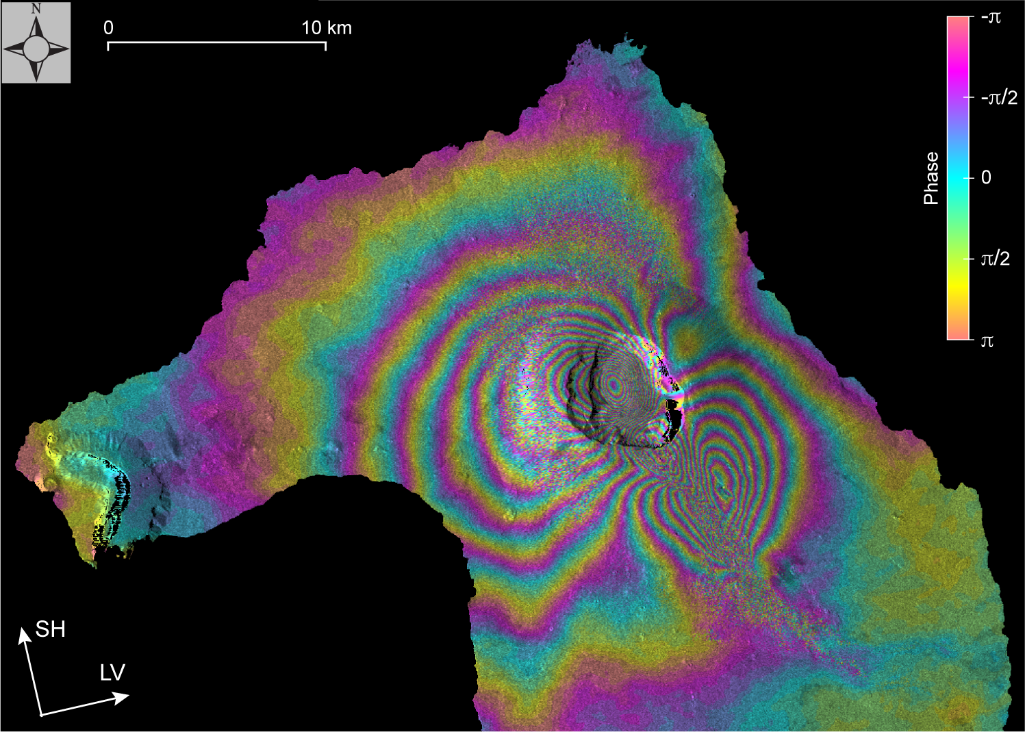
The KAUST team use satellite imagery, including radar images, to study the ground deformations and dike formations – the patterns of molten rock intrusions into surrounding solid rock associated with volcanic eruptions. Nobile first learned to make interferograms (images of land deformation created using radar data) during his Ph.D. He is so excited by them that he now creates them for fun as well as serious academic study.
“These magmatic processes produce large deformations that result in ‘fringes’ with a peculiar butterfly shape in the interferograms,” says Nobile. “I have a growing collection of dike intrusion interferograms from around the world, which, as well as being beautiful, are handy for teaching classes and prompting discussions on social media. Hopefully, we can also train a machine learning system to recognize dike formations from radar imaging data.”
Using interferograms, scientists can infer information about the source of the deformation, including the depth of the magma chamber, the underlying behavioral mechanisms and the interaction with the preexisting tectonic structures. “We can also track the evolution of lava flows and map new eruptive fractures or structures,” notes Nobile.
The 2022 Wolf eruption differs from that of 2015, when lava erupted from right around the rim of the caldera, suggesting that magma rose vertically from the magma chamber. In 2022, an eruptive fissure opened on the southwestern flank of the caldera, 2-3km from the rim. Nobile inferred this from the ground deformation patterns created by the magma moving beneath the surface (see image).
“Ultimately, the data we collect about volcanoes around the world is shared widely, used to create volcanic hazard maps and, whenever possible, for risk management,” says Nobile.
“With global coverage and routine data acquisitions of these radar satellites, the global research community is getting closer to regular monitoring of all of the approximate 1000 on-land volcanoes that are considered active,” adds Jónsson.
© 2022 KAUST; Sigurjón Jónsson